Monday, February 01, 2010
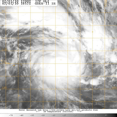
GOES-11 captured an infrared look at Oli’s clouds on Feb.1 at 1652 UTC (11: 52 a.m. ET). The storm appears to be well-defined.
The twelfth tropical cyclone in the Southern Pacific Ocean has formed today, February 1, 2010, and because of its proximity to the Fiji islands, it has been dubbed “Oli.” The GOES-11 satellite passed over Oli early this morning and captured an infrared image of the storm’s clouds.
GOES-11, or the Geostationary Operational Environmental Satellite, is operated by the National Oceanic and Atmospheric Administration and provides visible and infrared satellite imagery. Some of the imagery is created through the NASA GOES Project at NASA’s Goddard Space Flight Center in Greenbelt, Md. GOES-11 flew over Oli at 11:52 a.m. ET today, February 1, and noticed a well-organized tropical storm.
Oli’s name may also be referred to as Tropical Cyclone 12P in the news. The Fiji islands have their own list of tropical cyclone names, which may be confusing, because the Joint Typhoon Warning Center will typically use the number of the storm. The Joint Typhoon Warning Center is currently referring to Oli as “12P” for the twelfth tropical cyclone in the Southern Pacific Ocean.
At 10 a.m. ET, February 1, Tropical Storm Oli (12P) had maximum sustained winds near 57 mph (50 knots) up from 40 mph from 12 hours ago. Oli is moving east at 23 mph (20 knots). It was located about 540 nautical miles north-northwest of Rarotonga, near 13.5 degrees South and 162.9 degrees West.


0 comments:
Post a Comment