Friday, June 24, 2011
Summary
Severe Tropical Cyclone Yasi began developing as a tropical low northwest of Fiji on 29th January and started tracking on a general westward track. The system quickly intensified to a cyclone category to the north of Vanuatu and was named Yasi at 10pm on the 30th by Fiji Meteorological Service. Yasi maintained a westward track and rapidly intensified to a Category 2 by 10am on 31st January and then further to a Category 3 by 4pm on the same day.
Yasi maintained Category 3 intensity for the next 24 hours before being upgraded to a Category 4 at 7pm on 1st February. During this time, Yasi started to take a more west-southwestward movement and began to accelerate towards the tropical Queensland coast.
Yasi showed signs of further intensification and at 4am on 2nd February and was upgraded to a marginal Category 5 system. Yasi maintained this intensity and its west-southwest movement, making landfall on the southern tropical coast near Mission Beach between midnight and 1am early on Thursday 3rd February. Being such a strong and large system, Yasi maintained a strong core with damaging winds and heavy rain, tracking westwards across northern Queensland and finally weakened to a tropical low near Mount Isa around 10pm on 3rd February.
Yasi is one of the most powerful cyclones to have affected Queensland since records commenced. Previous cyclones of a comparable measured intensity include the 1899 cyclone Mahina in Princess Charlotte Bay, and the two cyclones of 1918 at Mackay (January) and Innisfail (March)
Wind Damage
At the time of writing there are no verified observations of the maximum wind gusts near thecyclone centre. However a barograph at the Tully Sugar Mill recorded a minimum pressure of 929 hPa as the eye passed over suggesting wind gusts of about 285 km/h were possible. This is supported by measurements (subject to verification) from instrumentation operated by the Queensland Government (Department of Environment and Resource Management) at Clump Point (near Mission Beach) which recorded a minimum pressure of 930hPa. Significant wind damage was reported between Innisfail and Townsville where the destructive core of the cyclone crossed the coast. Tully and Cardwell suffered major damage to structures and vegetation with the eye of the cyclone passing over Dunk Island and Tully around midnight on 2nd February.
The largest rainfall totals were near and to the south of the cyclone and were generally in the order of 200-300mm in the 24 hours to 9am Thursday. These rainfall totals were experienced in the area between Cairns and Ayr, causing some flooding. The highest totals were; South Mission Beach 471mm, Hawkins Creek 464mm, Zattas 407mm, Bulgun Creek 373mm along the Tully and Herbert River catchments.
Labels: cyclone, tropical cyclone, tropical storm
Thursday, June 02, 2011
This blog presents a data-rich view of climate and a discussion of how that data fits together into the scientists' current picture of our changing climate. But there's a great deal that we don't know about the future of Earth's climate and how climate change will affect humans.
Climate scientists often discuss "abrupt climate change," which includes the possibility of "tipping points" in the Earth's climate. Climate appears to have several states in which it is relatively stable over long periods of time. But when climate moves between those states, it can do so quickly (geologically speaking), in hundreds of years and even, in a handful of cases, in only a few decades. These rapid 'state changes' are what scientists mean by abrupt climate change. They are much more common at regional scales than at the global scale, but can be global. State changes have triggers, or tipping points. In what's probably the single largest uncertainty in climate science, scientists don't have much confidence that they know what those triggers are.
Below is an explanation of just a few other important uncertainties about climate change. This list isn't exhaustive. It is intended to illustrate the kinds of questions that scientists still ask about climate.
1. Solar Irradiance.
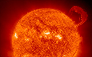
The sun has a well-known 11-year irradiance cycle that produces about .1% variation in output.1 Solar irradiance has been measured by satellite daily since the late 1970s, and this known solar cycle is incorporated into climate models. There is some evidence from proxy measurements-sunspot counts going back centuries, measurements from ancient trees, and others-that solar output varies over longer periods of time, too. While there is currently no evidence of a trend in solar output over the past half century, because there are no direct observations of solar output prior to the 1970s, climate scientists do not have much confidence that they understand longer-term solar changes. A number of U.S. and international spacecraft study the sun.
2. Aerosols, dust, smoke, and soot.
These come from both human and natural sources. They also have very different effects on climate. Sulfate aerosols, which result from burning coal, biomass, and volcanic eruptions, tend to cool the Earth. Increasing industrial emissions of sulfates is believed to have caused a cooling trend in the Northern Hemisphere from the 1940s to the 1970s. But other kinds of particles have the opposite effect. The global distribution of aerosols has only been tracked for about a decade from the ground and from satellites, but those measurements cannot yet reliably distinguish between types of particulates. So aerosol forcing is another substantial uncertainty in predictions of future climate.


